Bugging Out: Choosing the Best Travel Mode When Things Go Sideways
- madwrld42
- Jul 20, 2025
- 4 min read
When disaster hits and it's time to get your family out of harm’s way, choosing the right travel mode could literally save your life. Whether you're escaping a natural disaster, widespread blackout, or other SHTF (Stuff Hits The Fan) event, having a well-thought-out plan can make all the difference. At Mad World 42, we've studied the options so you don't have to. Here’s what you need to know about evacuating by foot, vehicle, bike, and more.
Evacuation Basics: Know Your Options
In emergencies, speed, distance, resources, accessibility, and safety become critical factors. Here's a quick look at how different travel modes stack up:
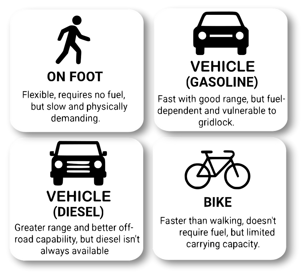
Travel Mode Breakdown

1. On Foot – Slow but Reliable
Walking is your ultimate backup plan. No gas needed, just good shoes and determination. But realistically, you're covering only 10-20 miles a day, even less with kids or elderly family members. While you’re free from traffic jams, you’ll need to carry everything on your back, making planning crucial.
Pro tip: Mad World 42’s Land Navigation & Routing Assessment, Education Service equips you with skills and tools to navigate routes and terrains.

2. Cars & Trucks – Fast but Fuel-Hungry
Vehicles can whisk your family hundreds of miles in a day, ideal if you're heading to a distant safe haven. Gasoline vehicles are widely used but fuel shortages can be devastating during mass evacuations. Diesel vehicles provide longer range and better off-road options, and
diesel fuel stores better over time—great for prepared preppers.
Expert advice: Check your vehicle's performance and reliability with Mad World 42’s Equipment and Technology Evaluation Service, ensuring your critical gear won't fail when it matters most.

3. Bikes – Balance of Speed and Independence
Cycling hits the sweet spot between walking and driving. It’s faster than walking and doesn't require gas. However, bicycles can only carry limited supplies, and not all family members may be able to ride comfortably. It’s an excellent backup option to keep handy.
Real-World Lessons
Hurricane Rita (2005) showed just how disastrous evacuating by car can become if millions hit the road simultaneously. Families spent hours or even days stuck in traffic, running out of fuel. Meanwhile, events like 9/11 and the 2003 Northeast blackout highlighted walking as the most immediate, albeit physically taxing, escape mode for many urban dwellers.
Finding Your Safe Place
Choosing your destination—your "safe place"—is critical. Consider factors like distance, available resources, healthcare access, and security.
Coming soon: Mad World 42's Routes Less Traveled (RLT) App helps you identify safe destinations and initial routes quickly and easily.
Plan, Prepare, and Practice

Evacuation isn’t just about picking a travel mode—it’s about being prepared for multiple scenarios. Ideally, your plan will include multiple layers:
Primary: Vehicle evacuation (car/truck).
Secondary: Bicycles as backups for shorter distances or congested routes.
Last Resort: Evacuating on foot if necessary.
Remember, real preparedness means being ready for anything—whether that’s traffic gridlock or fuel shortages.
The PATH System – Layered Evacuation Planning
To make sure you’re covered from all angles, consider using the PATH (Primary, Alternate, Tactical, Hidden) system. The PATH approach ensures you have multiple, prioritized escape routes:
Primary: Your fastest, most familiar route.
Alternate: A backup in case your primary route is blocked.
Tactical: Routes designed to avoid crowds and chokepoints.
Hidden: Secret or lesser-known paths for discreet evacuation.
This approach is an adaptation of the military PACE (Primary, Alternate, Contingency, Emergency) planning model, emphasizing redundancy in critical situations.
How Mad World 42 Helps You Stay Prepared
Custom Relocation Planning: Leveraging years of transportation-technology leadership and advanced geospatial analysis, we deliver evacuation plans tailored precisely to your home, workplace, or community.
Real Estate Planning and Assessment: Our advanced analytics evaluate properties for emergency readiness, bug-out feasibility, and long-term resilience.
Equipment and Technology Evaluation: Decades of expertise ensure your critical gear will perform reliably under pressure.
Land Navigation & Routing Education: We teach you practical navigation skills to confidently traverse complicated landscapes.
Bottom Line
No single travel mode fits all scenarios, and flexibility is key. Vehicles are ideal for long-distance escapes but rely heavily on fuel and clear roads. Walking and cycling provide independence and reliability but require physical readiness and careful planning.
With the right preparations—and support from Mad World 42—you’ll be ready to tackle whatever comes your way. Stay tuned for our upcoming blog on selecting and planning for your safe place!
References
Title | Summary |
An FHWA guide outlining five strategic approaches to managing pedestrian evacuations during emergencies, with a focus on planning, operations, and community safety. | |
Official FEMA guidance on evacuation planning for families, including how to prepare, when to evacuate, and what resources may be available during an emergency. | |
A detailed analysis of the planning and missteps that led to chaos during the Hurricane Rita evacuation, offering critical lessons for emergency managers. | |
A journalistic retrospective exploring how panic and poor planning created unprecedented traffic jams in Houston during the Hurricane Rita evacuation. |


Comments